
: failed to open stream: Invalid argument in <b>/home/servuzmq/minisites/siteT1/common/template/carteV2.php</b> on line <b>139</b><br />
)
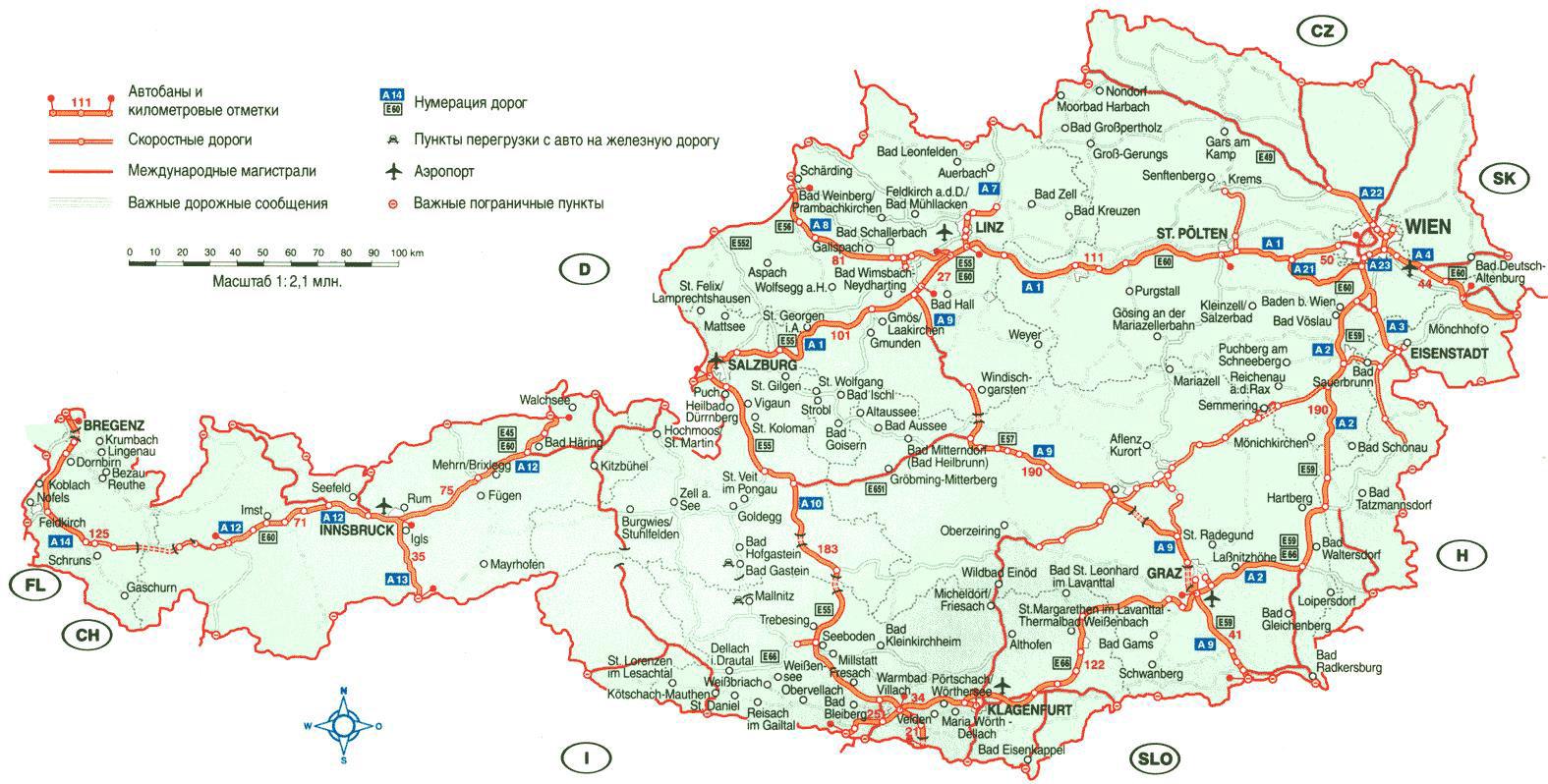
You can find on this page the Austria airports map to print and to download in PDF. The map of Austria airport presents details of location and international airports of Austria in Western Europe.
The Austria airports map shows location of airports in Austria. This airports map of Austria will allow you to determine which airport you will used to leave or arrive in Austria in Western Europe. The Austria international airports map is downloadable in PDF, printable and free.
The Vienna International airport is the largest airport in Austria and the main hub for Austrian airlines. The airport is located in Schwechat, some 18 km southeast of the city center as you can see in the Map of Austria airports. Getting from the airport to the center of Vienna takes less than 20 minutes with the CAT train. From the airport you can also continue by bus to several cities in Austria as well as Bratislava, Prague, Budapest and other international destinations. The Salzburg airport also called the Wolfgang Amadeus Mozart just a few km from the centre of Salzburg, which can be reached in 15 -20 minutes by train or bus. As the Salzburg airport is the gateway to the Ski Amade, the second largest skiing area in Europe, there is of course also direct connection from the airport to popular skiing resorts like St. Johann and Kitzbühel.
The airport in Innsbruck is the second largest “skiing” airport in Austria, the airport is located just 3 km from the centre of Innsbruck, from the airport there is a shuttle bus to the centre which takes about 20 minutes. Within 3 hours from the Innsbruck airport you have more than 400 skiing resorts, some of the nearest ones are Igls, Zell am Ziller, Worgl, Seefeld, Mutters, Soll, Solden as its shown in the Map of Austria airports. The Graz airport is located 9 km south of Graz centre. From the airport there is bus or S-Bahn to the center of town, travel time about 15 minutes. The airport is the main airport for the southeastern part of Austria and the alternative airport for travellers from the northeastern part of Slovenia. Cities nearby the airport include Wolfsberg, Leibnitz, Gleisdorf, Feldbach.
The Blue Danube Airport in Linz is located 13 km west of the city, the airport can be reached in 20 minutes by bus line 601 as its mentioned in the Map of Austria airports. The alternative is combinations of train and shuttle bus. Linz airport is not as close to all the skiing resorts like the Salzburg or Innsbruck airport, but flying to airport Linz is still an option. The travel time to some selected skiing resorts near Hinterstoder is less than one hour. The Kärnten airport in Klagenfurt is the smallest airport international airport in Austria. It’s located about 4 km from the center of town. The city can be reached by public bus or with S-bahn Klagenfurt Annabichl which is located 10 minute foot walk from the terminal. From the airport you can reach the following Austrian ski resortS in less than 3 hours, Gerlitzen, Bad Gestein, Alpendorf and also the following ski resorts in Slovenia, Kranjska Gora, Bled, Javornik, Vogel, Kobla, just to mention a few.