
: failed to open stream: Invalid argument in <b>/home/servuzmq/minisites/siteT1/common/template/carteV2.php</b> on line <b>139</b><br />
)
You can find on this page the Austria geographical map to print and to download in PDF. The Austria geographic map presents the topography, elevation, rivers, mountains, climate and physical features of Austria in Western Europe.
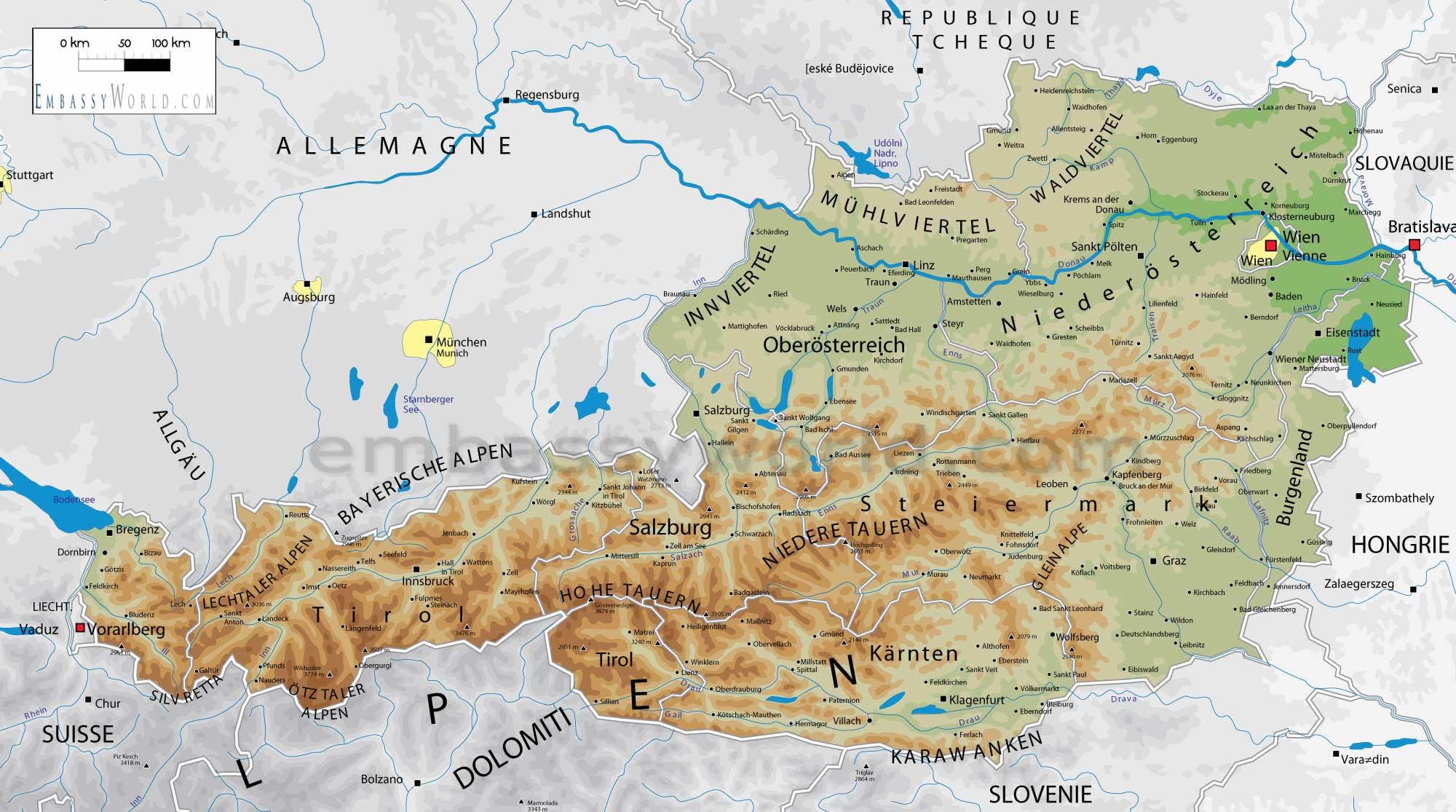
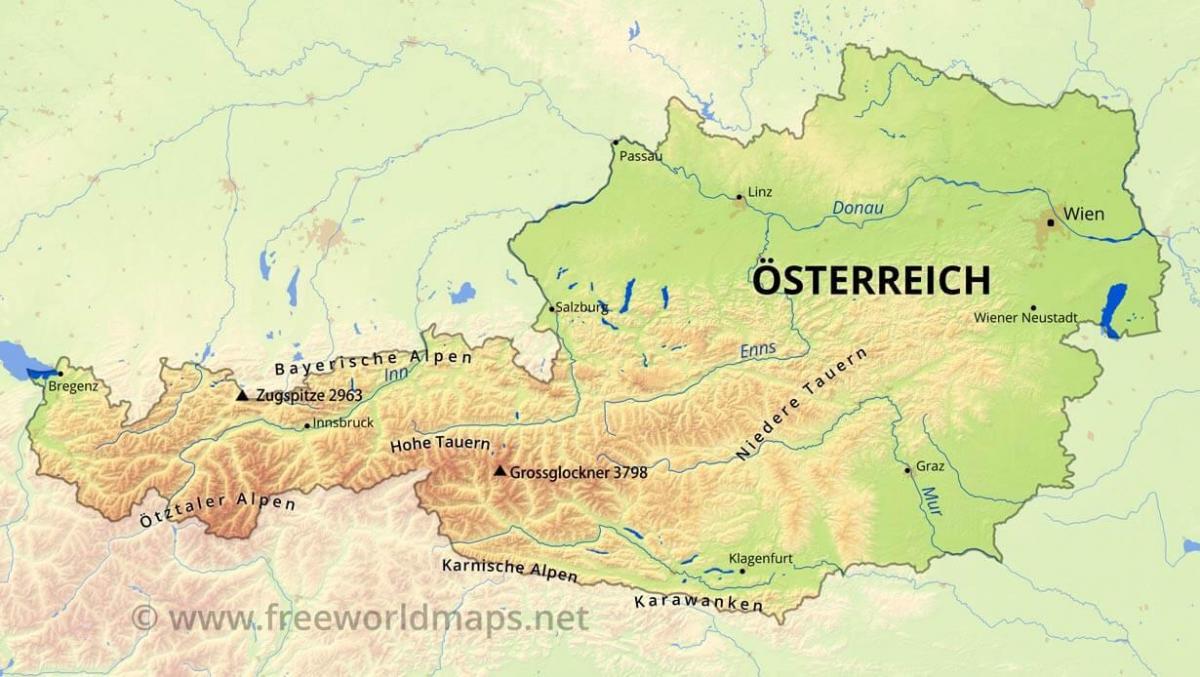
The Austria physical map shows landform and geography of Austria. This geographical map of Austria will allow you to discover physical features of Austria in Western Europe. The Austria physical map is downloadable in PDF, printable and free.
Austria is a small, predominantly mountainous country in Central Europe, approx. between Germany, Italy and Hungary. It has a total area of 83,859 km², about twice the size of Switzerland and slightly smaller than the state of Maine as you can see in Austria physical map. The landlocked country shares national borders with Switzerland (164 km) and the tiny principality of Liechtenstein (35 km) to the west, Germany (784 km) and the Czech Republic (362 km) and Slovakia (91 km) to the north, Hungary to the east (346 km), and Slovenia (311 km) and Italy (430 km) to the south (total: 2563 km).
The westernmost third of the somewhat pear-shaped country consists of a narrow corridor between Germany and Italy that is between thirty-two and sixty km wide. The rest of Austria lies to the east and has a maximum north–south width of 280 km as its shown in Austria physical map. The country measures almost 600 km in length, extending from Lake Constance (German Bodensee) on the Austrian-Swiss-German border in the west to the Neusiedler See on the Austrian-Hungarian border in the east. The contrast between these two lakes – one in the Alps and the other a typical steppe lake on the westernmost fringe of the Hungarian Plain – illustrates the diversity of Austria landscape. Austria may be divided into three unequal physical areas. The granite massif of the Bohemian Forest (known in German as the Böhmerwald), a low mountain range with bare and windswept plateaus and a harsh climate, is located north of the Danube Valley and covers the remaining 10% of Austria area. Notable is the Manhartsberg a granite ridge which separates Waldviertel from Weinviertel.
The largest part of Austria (62%) is occupied by the relatively young mountains of the Alps, but in the east, these give way to a part of the Pannonian plain, and north of the River Danube lies the Böhmerwald, an older, but lower, granite mountain range as its mentioned in Austria physical map. The Danube has its source near Donaueschingen in southwestern Germany and flows through Austria before emptying into the Black Sea. It is the only major European river that flows eastwards, and its importance as an inland waterway has been enhanced by the completion in 1992 of the Rhine-Main-Danube Canal in Bavaria, which connects the Rhine and Main rivers with the Danube and makes barge traffic from the North Sea to the Black Sea possible. Three major ranges of the Alps – the Northern Calcareous Alps, Central Alps, and Southern Calcareous Alps – run west to east through Austria. The Central Alps, which consist largely of a granite base, are the largest and highest ranges in Austria.
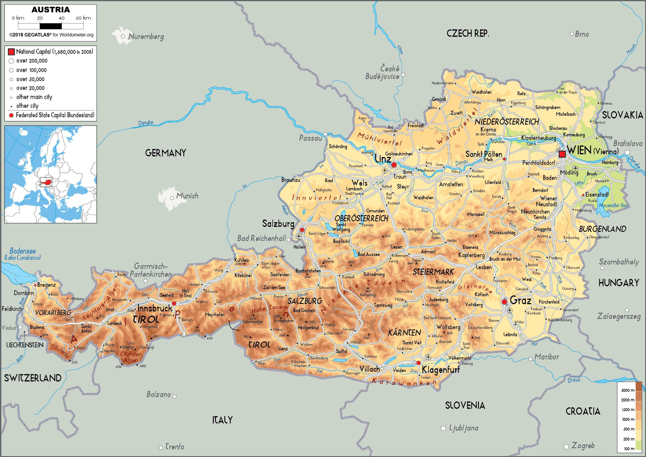
Austria topographic map shows the physical features of Austria. This topographical map of Austria will allow you to discover landforms and geographical of Austria in Western Europe. The Austria topographic map is downloadable in PDF, printable and free.
Austria is a landlocked country, known for its rugged terrain because of its central position in the Alps. The country is situated in Central Europe with Italy and Slovenia to the south, Hungary to the southeast, Slovakia to the east, the Czech Republic to the north, Germany to the northwest, as well as Switzerland and Liechtenstein to the west. In the northeast, Austria is mostly flat or gentle-sloping as you can see in Austria topographic map. This is where most of Austria population is concentrated, including its most populous and capital city, Vienna.
Austria terrain is highly mountainous due to the presence of the Alps; only 32% of the country is below 500 metres (1,640 ft), and its highest point the Grossglockner is 3,798 metres (12,460 ft) as its shown in Austria topographic map. The majority of the population speaks German, which is also the country official language. The highest point of the Austrian Alps is the Grossglockner, 3,797 m (12,457 ft). The Danube (Donau) River, fully navigable along its 350-km (217-mi) course through northeastern Austria, is the chief waterway, and several important streams—the Inn, Enns, Drava (Drau), and Mur—are tributaries to it. Included within Austria are many Alpine lakes, most of the Neusiedler See (the lowest point in Austria, 115 m/377 ft above sea level), and part of Lake Constance (Bodensee).
Most of western and central Austria is mountainous, and much of the flatter area to the east is hilly, but a series of passes and valleys permits travel within the country and has made Austria an important bridge between various sections of Europe. The principal topographic regions are the Alps, constituting 62.8% of Austria's land area; the Alpine and Carpathian foothills (11.3%); the Pannonian lowlands of the east (11.3%); the granite and gneiss highlands of the Bohemian Massif (10.1%); and the Vienna Basin (4.4%) as its mentioned in Austria topographic map.
The Austria elevation map shows the different altitudes of Austria. This altitude map of Austria will allow you to know where are the highest and lowest regions of Austria in Western Europe. The Austria elevation map is downloadable in PDF, printable and free.
The Alps is a dominant feature in Austria as it spans a large portion of the country from west to south. At 3,798 meters (12,461 ft) high within the Alps, its highest point is a peak known as the Grossglockner in west-central Austria as you can see in Austria elevation map. But in the northeast, Austria is mostly flat or gentle-sloping with the highest concentration of Austria population. While its largest lake is Lake Constance (known as the Bodensee), its longest river is the Danube River.
The Grossglockner (German: Großglockner, Slovene: Veliki Klek) is, at 3,798 m above sea level, Austria highest elevation mountain and the highest mountain in the Alps east of the Brenner Pass as its shown in Austria elevation map. This makes it, after Mont Blanc, the second most prominent mountain in the Alps, when measured by relative height; see the list of Alpine peaks by prominence. The Grossglockner lies on the border between Carinthia and the East Tyrol; it is the highest peak in the Glockner group, a group of mountains along the main ridge of the Hohe Tauern. The summit itself lies on the Glockner ridge, which branches to the south off the main ridge. The Pasterze, Austria biggest glacier, lies at the Grossglockner foot. The characteristically pyramid-shaped peak actually consists of two pinnacles, the Grossglockner and the Kleinglockner (3,770 m; klein means "small" in German), separated by a saddle-like formation known as the Glocknerscharte.
Austria is known all over the world as a mountain country and with the Alps accounting for almost 2/3 of Austria total surface area, the country does indeed live up to its nickname "Alpine Republic". Therefore many tourists are surprised when they come for the first time into the flat, almost endlessly wide landscape of the Seewinkel, which at the same time represents the lowest situated area of Austria. On average, the Seewinkel is only 120 metres above sea level. At our present location, the lowest elevation point in Austria, the sea level is only 114 metres, which is Hedwighof (Municipality Apetlon, at 114 m, 47°52′N 16°45′E / 47.867°N 16.75°E as its mentioned in Austria elevation map.
The rivers in Austria map shows the principal rivers with their names of Austria. The rivers map of Austria will allow you to find the main rivers which flow in and through Austria in Western Europe. The Austria rivers map is downloadable in PDF, printable and free.
Some of the longest rivers in Europe like the Danube pass through Austria. All the Austrian rivers flow into either the Black Sea or the North Sea. The Danube is the second-longest river in Europe right after River Volga. The 1,770-miles long Danube River is situated in Eastern and Central Europe as you can see in Austria rivers map. The Danube flows through 10 states, (which is the highest number for any river on earth). It rises in Donaueschingen town, Germany and flows through Ukraine, Moldova, Bulgaria, Serbia, Romania, Croatia, Slovakia, Hungary, and Austria before flowing into the Black Sea. The Danube rises at the confluence between the Breg and Brigach rivers. River Danube drainage basin stretches into nine nations including Albania, Macedonia, Poland, Switzerland, Montenegro, Slovenia, Czech, and Bosnia and Herzegovina.
The Rhine River is one of the longest rivers in Central and West Europe that rises from the Graubunden in Switzerland. The Rhine forms part of Liechtenstein-Switzerland, Austria-Switzerland, German-Switzerland, and Germany-France boundaries and then flows through the Rhineland and Holland before emptying into the North Sea as its shown in Austria rivers map. The 760-mile long river was a huge part of the Roman Empire northern inland frontier, and it has been an important navigable river for carrying goods and trade inland. The Drava is the third-longest river in Austria and one of the longest branches of the Danube. River Drava rises from Puster Valley in Italy and then flow eastwards to Styria, Slovenia through Carinthia and East Tirol in Austria. The river turns southeast and passes through Croatia before merging with River Mur (one of its main tributaries). It then forms part of the Hungary-Croatia boundary before joining the Danube. The Drava is one of the world’s most exploited rivers in terms of hydro-power.
River Inn is a 322-mile long river that flows through Germany, Austria, and Switzerland. The source of the River Inn is situated in the Swiss Alps. From its source, the Inn flows through two large lakes (Lake Silvaplana and Lake Sils) as its mentioned in Austria rivers map. It then flows in Austria where it passes through Landeck, Tyrol, and Innsbruck and then stretches into Bavaria. In Bavaria, it merges with its two main tributaries the Salzach and Alz rivers. The Inn forms part of the Austria-Bavaria border before emptying into the Danube. Some of the branches of the Inn include Pitzbach, Hartbach, Rott, and Kieferbach rives among others. Other than providing water for irrigation, the Austrian rivers produce over 65.7% of the country national electricity. Austria is home to one of the most exploited rivers in the world when it comes to hydropower. Due to its position in the Alps, the country rivers have one of the highest hydropower potentials in Europe. Currently, there are over 5,200 hydropower facilities in Austria with about 2,882 plants feeding the country electrical grid.
The mountains in Austria map shows the principal mountains with their names in Austria. The mountains map of Austria will allow you to find the main mountains ranges and highest mountains of Austria in Western Europe. The Austria mountains map is downloadable in PDF, printable and free.
There are 242 peaks in the country over 3000 metres, with at least 150 metres of prominence. There are twelve mountains in Austria over 1,500m of prominence and fifty-eight over 600m of prominence as you can see in Austria mountains map. Wildspitze is the highest mountain in the Ötztal Alps and the second highest mountain in Austria after the Großglockner. The large number of glaciers and relatively easy routes make it popular with ice climbers (especially the North face). The first ascent of the southern peak was accomplished in 1848 by Leander Klotz and an unknown farmer of the region. The even higher northern peak was also first climbed by Leander Klotz. Weißkugel (Italian: Palla Bianca) is the second highest mountain in the Ötztal Alps and the third highest mountain in Austria. Featuring many glaciers, it lies on the border between Austria and Italy. The easiest way to climb it is over its southern side. It was first climbed in 1850 by J.A. Specht, Leander Klotz, and Nicodem Klotz. Due to its central location, it has one of the best views in the entire Alps. Though not easily picked out among the mountains, its peak can be seen from Venice.
The Austrian Northern Limestone Alps, the northern flank of which borders Germany as its shown in Austria mountains map. The main mountain groups in the range in Austria, moving from west to east are Vorarlberg, Lechtaler, Allgäuer, Ammergauer, Wettersteingebirge, Mieminger Gebirge, Karwendel, Reite, Mangfall Gebirge, Chiemgauer, Steinernes Meer, Salzkammergut, Totes Gebirge, Eisenwurzen and the Alpine foothills of the Wienerwald. Further details of these ranges can be obtained via the hyperlinks here. The highest Austrian mountain in the range is the Parseierspitze (3036m) in the Lechtaler Alpen. This has a prominence of 1243 metres. The Austrian Southern Limestone Alps, the southern flank of which borders on Italy and Slovenia. The main mountain groups in Austria, moving from west to east, are Karnischer, Gailtaler, Karawanken, Steiner and Bachergebirge. Further details of these ranges can be obtained via the hyperlinks here. The highest Austrian mountain in the range is Hohe Warte (2780m). This has a prominence of 1144 metres.
The western and central parts of the country are in the Alpine region and are very mountainous, with over two-thirds of the country above an altitude of 500 metres, and much above 1000 metres as its mentioned in Austria mountains map. The Austrian Central Alps, composed principally of volcanic rocks, in which are most of the highest mountains in Austria, bordering on the Swiss and Italian frontiers on their western and southern edges. The main mountain groups in Austria, moving from west to east, are Sesvenna, Silvretta, Rätikon, Verwall, Samnaun, Öztaler, Stubaier, Tux, Zillertaler, Kitzbühler, Hohe Tauern, Niedere Tauern, Lavantaller, Hochwesel, Fischbacher and Grazer Bergland. Further details of these ranges can be obtained via the hyperlinks here. The highest mountain in the range is the Großglockner (3,798m) in the Hohe Tauern.
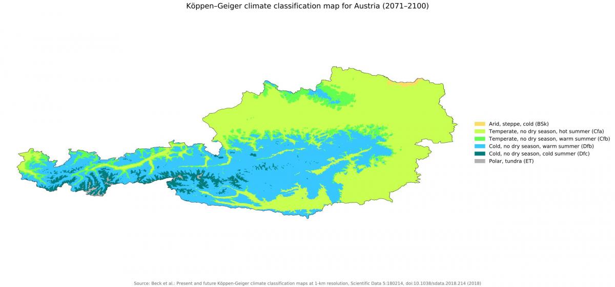
The Austria climate map shows average temperature and climate zones of Austria. This climate map of Austria will allow you to know weather, average precipitation, average sunshine and different climates of Austria in Western Europe. The Austria climate map is downloadable in PDF, printable and free.
The Alps serve as a watershed for Europe three major kinds of weather systems that influence Austrian weather. The Atlantic maritime climate from the northwest is characterized by low pressure fronts, mild air from the Gulf Stream, and precipitation as you can see in Austria climate map. It has the greatest influence on the northern slopes of the Alps, the Northern Alpine Foreland, and the Danube valley. The continental climate is characterized by low pressure fronts with precipitation in summer and high pressure systems with cold and dry air in winter. It affects mainly eastern Austria. Mediterranean high-pressure systems from the south are characterized by few clouds and warm air, and they influence the weather of the southern slopes of the Alps and that of the Southeastern Alpine Foreland, making them the most temperate part of Austria.
One peculiarity of the Mediterranean weather systems is the föhn wind, a warm air mass that originates in the African Sahara and moves north rapidly, periodically raising temperatures up to 10 °C (18.0 °F) in a short period of time as its shown in Austria climate map. Many people respond to this rapid weather change with headaches, irritability, and circulatory problems. During the winter, the rapid warming that accompanies a föhn can thaw the snow cover in the Alps to such an extent that avalanches occur. Given the importance of Alpine skiing for the Austrian tourist industry, December is the month during which the weather is watched with the greatest anticipation. As a rule, Atlantic maritime weather systems bring snow, and continental weather systems help keep it. However, a predominance of cold, dry continental systems or warm Mediterranean ones inevitably postpone the beginning of the ski season. In the summer, Mediterranean high-pressure systems bring warm, sunny weather.
The climate of Austria can be classified as Cfb Climate; a warm temperated humid climate with the warmest month lower than 72 degrees Fahrenheit (22 degrees Celsius) over average and four or more months above 50 (10 degrees Celsius) over average as its mentioned in Austria climate map. The climate of the Mountainous Regions of Austria can be classified as Dfb Climate; a humid snow climate with the warmest month between 50 and 72 degrees Fahrenheit (10 – 22 degrees Celsius), the coldest month below 26 degrees Fahrenheit (-3 degrees Celsius) and at last four or more months above 50 degrees Fahrenheit (10 degrees Celsius). The coldest month in Austria is usually January. The winter snow cover lasts from late December through March in the valleys, from November through May at about 5,905 ft or 1,800 m, and becomes in many years permanent above about 8,202 ft or 2,500 m.


